Work at 278 O'Connor proceeds apace — photo from April of this year. See last year's discussion here.
Thursday, May 26, 2022
Tuesday, May 24, 2022
Come to Bedrock, 1901
Well here's a clip-and-save for you. While our understanding of Ottawa's lithic underpinnings has evolved over the last 120 years (and the nomenclature has been tweaked a few times), this gorgeous bedrock map from 1901 has much to teach us. As always, click on the image, then right-click > view in a new tab and enlarge to properly appreciate this map's lovely detail.
Monday, May 23, 2022
Formerly the Cathay House
I was genuinely surprised to learn that the intersection of Albert and Bank was once the heart of Ottawa's Chinatown. I won't pretend to be any sort of expert on the subject, but i do offer three scans from the old Ottawa Journal that offer a barest whiff of how Chinese cuisine was perceived and welcomed as it crossed over to the "mainstream" after WWII. From 1946, less than a year after the war ended, and then from ten years later.
(Click on the images to render them readably large.)
... and from 1956, still being treated as an exotic novelty. Forgive if i say that "Ho-Ho Cafe" suggests a joke on a par with the guy who wants to get some "Chinese writing" tattooed, and ends up getting "chicken fried rice" written over his heart.
No, i don't think she's going to eat it all herself.
"I Give Away!"
Founded in the US in 1926, the initials actually stood for the International Grocers Alliance, but their "I give away!" slogan sure got people's attention. The ad dates from 1955 by which year Ottawa/Hull had over 30 affiliate stores, operating on what was more or less a franchise basis.
Wikipedia has a decent overview of IGA's presence in Canada here.
For External Use Only
Methanol, methyl alcohol, methyl hydrate, wood alcohol — call it what you like, just DON'T fucking drink the stuff.
The Canadian Industrial Alcohol Company, Ltd. of Montreal, seems to have gotten their hands on a windfall of advertising dollars in the spring of 1923, when almost all of their advertising appeared in one fell swoop.
Orange Tarps on the Rideau
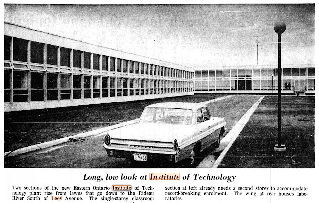
Here's a faux-Polariod i shot about a month ago, on one of my first bike rides of the year. Evidently, uOttawa is rebuilding the entire western half of its Lees Avenue campus from the ground up, part of a larger modernization project. The OOE Mainstreeter has an article here. For many years the eastern campus of Algonquin College, the post-secondary facility opened as the Eastern Ontario Technical Institute (EOTI) in the fall of 1964. Prior to WWII, the site was a garbage dump.
Here's a "long, low" shot of the original buildings from August 1964 via the Ottawa Citizen.
Overgrown
Curiously, this stretch of path is all that remains of part of the north end of "old" Riverside Drive. Consider this aerial comparison. In the upper image (2019) i've drawn a yellow oval around that part of the woods where the path runs.
The lower image (1928) shows what was then Riverside Drive (then just a dirt road) running to the east of the old Hurdman farmstead.
Here's the Old Riverside Drive (yellow arrows) on a 1906 top map (detail.) In fact, this roadway appears at least as far back as H. F. Walling's 1863 map of the area.
The now-overgrown section of Riverside Drive was cut off from traffic when the Queensway bridge was opened in the 1960s. The section south of Hurdman Station was repurposed as bus transitway.


